


Cala Galdana

*Cala Santa Galdana:*
It is a beautiful horseshoe-shaped beach, spacious with considerable dimensions and fine sand, with an entrance that does not easily reveal the pearl it guards inside. Flanked by high walls that protect it from the weather, the beach of Cala Galdana is adorned by a rocky promontory called "the Island," surely because in the past when the river of Cala Galdana brought more water, it would flood part of the beach right up to the crag, temporarily turning it into an islet, which even has some pine trees on its crest.
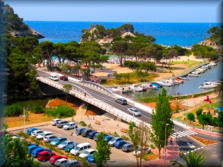
The promontory, perfectly accessible from the beach, has a pedestrian bridge at the back that connects it with the Serpentona development, crossing over the river of Cala Galdana and the cove's nautical activities area, which has numerous moorings for fishing and recreational boats in the stretch from the mouth to the Cala Galdana bridge 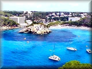
The crag known as La Isla has a bar-restaurant with unbeatable views of the bay and the beach of Cala Galdana itself. It even has a large opening, a natural window that allows you to see the waves crashing against the rocks on the other side. Next to this natural window cave, continuing towards the point of the rocks, are the remains of some Casemates/Trenches, tunnels and rooms for the militias that defended the beach position to prevent enemy landings; the point is very protected and, like almost all of them, is 90% excavated into the living rock with the rest being well camouflaged.

Serpentona is the residential area of Cala Galdana, which is found after crossing the River of Cala Galdana.
This geographical feature is the boundary of the municipalities of Ciutadella and Ferreries, the latter of which contains the cove and the entire beach area.
Thus, Ciutadella is represented by the Serpentona development, accessed by crossing a modern, recently built bridge that has a very modernist profile with wide arches. It is said to be the first bridge in the world whose structure was built entirely of stainless steel, upon which the concrete formwork of the urban road rests.
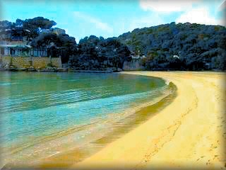
It is also a stop for the “golondrinas” (tourist boats) that take excursions to virgin coves, as well as boats from the scuba diving school. This place is popularly called “the island” because it looks like an islet joined by a bridge that passes behind it, but it is actually to bridge the freshwater outlet of the torrent that meanders slowly through the barranco de Algendar. In its final stretch, this turns into a jetty and port for the fishing and recreational boats of residents in Cala Galdana or Serpentona. This torrent follows part of the beach of Cala Galdana, acting as a natural barrier—a political one first, as it is the geographic dividing line between the Municipality of Ferreries, where the entirety of the beach of Cala Santa Galdana and the  development are located, and the Municipality of Ciutadella, where the Serpentona development is found. The other barrier is more aesthetic, as it separates the road and the most commercial area of the development. In the central area of the beach, there is a pine forest where a couple of beach bars are located; then we find more service areas with bars, restaurants, and a large hotel right at the feet of the sand. But it is not the only one. The beach ends abruptly against a cliff that is somewhat shaded in the mornings. On this side, the waters become deeper and it is usually the preferred spot for yachts to anchor at free anchor, as the only anchorage in the beach area is next to the Island, and it is only used for the disembarkation of passengers from the golondrinas. Taking advantage of the fact that Cala Galdana is in the middle of a series of virgin beaches, they use it as a base, for departure or as a stop to eat in one of the restaurants in the area, and they take excursions touring the virgin beaches of Macarella, Talaier and Son Xoriguer to the right, or Mitjana, Trebaluger, Fustam, Escorxada, and Adeodato to the left.

1) Artrutx Lighthouse, Ciutadella
List of the Beaches
2) Calan Bosch Ciutadella urbanized beach
3) Son Xoriguer Ciutadella urbanized beach
6) Son Saura Ciutadella virgin beach
7) Talaier Ciutadella virgin beach
8) Calan Turqueta Ciutadella virgin beach
9) Macarella and Macarelleta Ciutadella virgin beach
10) Cala Galdana, Ferreries urbanized beach
11) Mitjana and Mitjaneta Ferreries virgin beach
12) Trebaluger Ferreries virgin beach
13) Fustam Ferreries virgin beach
14) Escorxada Ferreries virgin beach
15) Adeodato Es Migjorn Gran virgin beach
16) Binigaus Es Migjorn Gran virgin beach
17) Santo Tomas, Es Migjorn Gran urbanized beach
Son Bou, Alaior (Mitjana of Santo Tomas does not appear on the map) urbanized beach
Beach Viewpoints

The top of the cliff features several viewpoints that allow us to appreciate the beauty of the cove in all its fullness. Furthermore, it is recommended to walk around the residential area, which has grown significantly in recent years and offers a wide and varied range of tourist services during the summer months, including all types of apartments and large hotels, a campsite (on the road), laundry services, as well as playgrounds for children and entertainment for adults, diving courses, but above all, a very wide range of dining options for all tastes and palates. It also has a garden center and a large horse show park (both on the road), especially suitable for the whole family, and which is located halfway along the access road to Cala Galdana.

Cala Mitjana and Mitjaneta:
It is one of those idyllic places on the south coast of Menorca. This is another virgin beach and a bastion of nature conservation in the municipality of Ferreries, a place to feel all the good sensations that a beautiful landscape can convey to a sensitive person.
Cala Macarella and Macarelleta are well sheltered from the winds by cliffs that form a fairly deep inlet, with abundant trees, making it ideal for spending a very 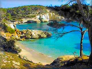 pleasant day walking in the surroundings, taking photos, and enjoying the views.
From the cliffs in the area, despite being a virgin area, there is a good parking lot 150 meters from the water and sanitary services (only in summer), controlled by guards who also limit capacity to preserve this natural area.
Excursions: From here, you can make two outings to virgin coves, which are also considered iconic.
We recommend two starting from this residential area: Cala Mitjana and Cala Macarella, but if you wish, you can visit more virgin coves simply by continuing on from either of these two.
Cala Trebaluger:
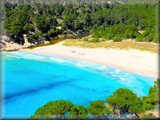
The virgin beaches of Trebaluger, Fustam, and Escorxada are also recommended (See Trebalúger Area).
Access: From Ferreries, just where the town ends in the direction of Ciutadella, on the left, begins the road to Cala Galdana (PM-714) at a distance of 5.5 km.
At 1.5 km, there is the venue where the Menorcan horse breed show takes place; it is an EQUESTRIAN SHOW worth seeing.
To go to the virgin coves:
Cala Mitjana: 1 km before entering the residential area, on the left, there is a rural dirt path that leads directly to the parking lot of Cala Mitjana. If you wish to go to any of the other three coves, see the comment about this cove above.
Cala Macarella: If you have decided to walk to this cove, take the path that leaves from behind the bridge at the end of the beach of Cala Galdana, on the right side; this leads to Macarella, 40 minutes away. Remember that you can also arrive by vehicle from Ciutadella (for more information, see Virgin Coves of the South).
Access the online map of the Cala Galdana area
Map of the Cala Galdana area

Access map to the Cala Galdana area and the virgin beaches of Mitjana and Macarella:
1 -) Roundabout at the entrance to the Cala Galdana residential area:
A-) Straight ahead to the beach and the central commercial area of Cala Galdana.
B-) Left to the upper part and the best viewpoints of Cala Galdana Beach.
C-) To the right to the Algendar barranco Viewpoint and the Cala Galdana river.
2 -) Cala Galdana bridge, separates Ferreries from Ciutadella.
3 -) Commercial area, shopping center of Cala Galdana.
4 -) Cala Galdana beach.
5 -) Viewpoint of Cala Galdana beach, beautiful views, photo point.
6 -) Viewpoint of Cala Galdana beach, spectacular panoramic view of the entire cove, the beach, and the surroundings.
7 -) River viewpoint, panoramic views of the Algendar barranco and the river that snakes along the bottom of the ravine, view of the Serpentona residential area.
8 -) Cala Mitjana and Mitjaneta, virgin beaches. The entrance to access this beach is 0.5 km before reaching the access roundabout to the Cala Galdana residential area, that is to say, point (1) on this map.
9 - 10 -) Cala Macarella and Macarelleta, virgin beaches. The access to this virgin area is located just in front of the pedestrian bridge at the end of Cala Galdana beach. From here, you can only go on foot, and the excursion takes about 20 to 30 minutes one way; the path is wide, well-signposted, and runs almost the entire time through a Mediterranean pine forest area.
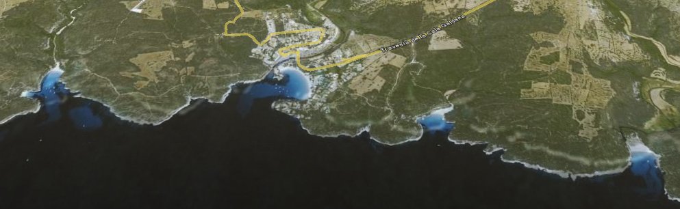
See the three-dimensional map of the coastal profile corresponding to this itinerary of the Cala Galdana area.
Copyright Islademenorca.es, total or partial reproduction prohibited.
Photographs: Omar Mauro Banquero